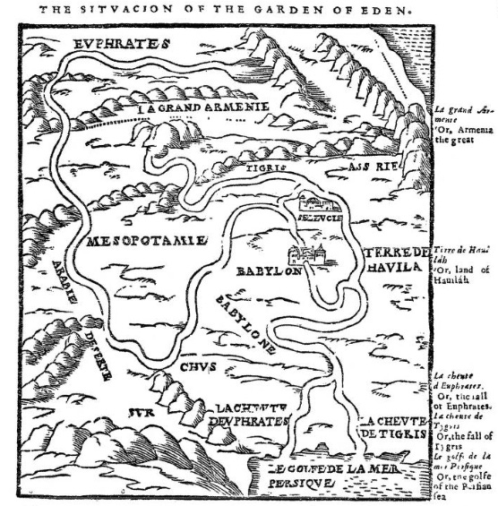
This description of Eden taken out of Genesis chapter 2, as well as the map and its subtext, are from the 1560 Geneva Bible, and if you pay close attention the biblical description does not seem to support the map. The placement of Eden in Mesopotamia is admittedly speculative, as you can see in note f alongside the passage.
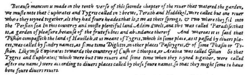
So, to start, the garden is in Eden, the garden is not Eden. “Out of Eden went a river.” That indicates that the headwater of the river through the garden was somewhere in Eden, whether inside or outside of the garden. After or as it passed by or through the garden, it “became into four heads.” The subtext to the map indicates that two of these are the source sides of the Tigris and Euphrates, and the other two are the branches that flow into the sea. But the word “head” would indicate the source of a river, not its termination, so unless the sea is flowing into the river, the explanatory subtext doesn’t make sense. The map doesn’t really work as Eden in the period of Adam and Eve.
Now, since this map seems to be a contemporary depiction of the topography of the Tigris and Euphrates area, a question arises: was it reasonable to place Eden along presently-known rivers when pre-flood topography may have been significantly different than post-flood topography? Maybe the flood wiped the rivers out or changed the area drastically.
Well, the names of all of these rivers are actually in the Bible again post-flood, except for Pishon. So either the map shows the location of Eden with its contemporary post-flood topology, or it shows an unrelated contemporary location marked with biblical names.